


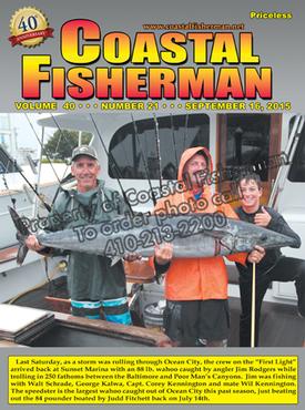
Article by Capt. Steve Katz
 What is a heading sensor?
Before we can talk about the electronic heading sensor, let’s review some navigational terms. For some, these terms can be confusing at times and easily misunderstood. This is often the case when it comes to navigation and the ships heading.
Course over the Ground (COG) - this is calculated automatically by the GPS; it takes several positional fixes per second and plots them on a digital chart. The direction of the track created by this succession of position fixes is your Course over the Ground. This is NOT the ships heading.
Bearing to Waypoint (BNG) or Course to Waypoint (CSE) or Course to Steer (CTS) - This is calculated by the GPS and is the compass direction from your vessel to the waypoint you have chosen, the bearing is calculated at your initial location and may need to be re-calculated if you become of-course on your journey.
True North and Magnetic north - These are not in the same place, they are two different angular measurements. The ship's compass will align itself with the magnetic field it 'sees'. This may or may not be the same as the Earth's magnetic field due to possible interference. Boaters may use either magnetic or true, though be sure you know which you are using and that all of your equipment is set-up for the same chosen North.
Magnetic Variation - Is the horizontal angle (or difference) between true north and magnetic north, measured east or west of true north.
Now that we have the terminology covered, let’s review the heading sensor. Modern electronics often need to know the ships heading to properly display information on the screen such as a radar overlay. A radar overlay is when the GPS chart plotter overlays the radar screen image over an electronic chart in a fashion that allows you to see both the radar and chart at the same time. This can be extremely useful as a navigation and collision avoidance tool. In order for this to work properly and accurately, the chartplotter needs to know the actual heading (not course) so it can precisely adjust the radar image in regards to the front of your boat.
If you are using a Garmin chartplotter, you may be wondering what all the fuss is about, since Garmin is one of the few companies that can show a radar overlay without a heading sensor, using the calculated GPS course.
If you have Furuno or Simrad/Lowrance you will need a heading sensor to enable radar overlay. As we reviewed above, the ships heading and course over ground many not be the same. For example, steering the bow into the wind or current but traveling in a slightly different direction (sometimes called crabbing). To produce the most accurate radar overlay, we need a heading sensor to tell the chartplotter exactly where the bow is pointed and not just the direction of travel.
A heading sensor is similar to the standard ships compass you many have on the helm, but instead of a clear window to read the card, electronic sensors read the card electronically and now most modern heading sensors consist of a solid state components without a moving card. These heading sensors often contain a 3-axis rate gyro with a 3-axis accelerometer or even a 9 axis solid-state gyro. These heading sensors output electronic data using industry standard protocol such as NMEA0183 or NMEA2000 and is read by the modern GPS chartplotters.
A heading sensor needs to be calibrated, either automatically or manually depending on the exact model. If the heading sensor is not calibrated, it can cause your boat icon to be pointed in the wrong direction on your chart plotter.
You may already have a heading sensor on-board; most autopilot systems incorporate a heading sensor as part of the electronics that keep your boat on-track when the autopilot is engaged. Often, this same heading information can be shared and sent to the modern GPS chartplotter for use as a heading sensor. While this often works, it is best to have an independent heading sensor as part of your navigation electronics package.
Using a heading sensor with a marine radar system allows for even more features than radar overlay, such as Mini-Automatic Radar Plotting Aid (MARPA) target tracking, real motion target trails, and radar chart overlay that matches on the chart what your bow is really pointing to. It is also reassuring to be able to acquire a target on the radar, and within a few sweeps, know its heading and speed.
Because of the features gained in the radar capability alone, the purchase of a heading sensor may be one of the most value packed electronics investments you can make beginning at a few hundred dollars. Now when you choose "heading up" orientation on a chartplotter, the bow is really pointing at what the chart shows even if you are stopped or slow, circling for that perfect fishing spot.
Captain Steve Katz is the owner of Steve’s Marine Service and holds NMEA, AMEI and NMEA2000 certificates along with ABYC Master Technician certification and factory training from many manufacturers.


